Tourist
attractions from Cabana Transalpina Rânca
Easy walks from Cabana Transalpina:
To
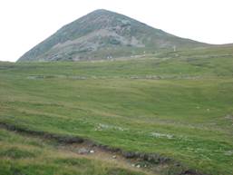
the peak Corneșul Mic (1698m), duration 1 hour both ways. On the main road
till Hotel Onix, then up to the top of the old ski slope M1.
To
the peak Corneșul Mare (1686m), duration 1h30
both ways.
On the main road till Cabana Ingrid, then up the hill till the water
reservoirs.
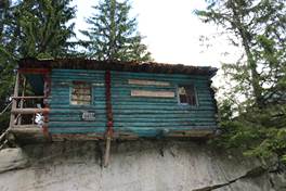
To
the shepherd’s hut. From the base of the new ski slope, 30 more minute
on the unpaved road. You can eat traditional food (cornmeal with
cheese
and sour cream) made by the shepherd’s wife.
Mountain hiking trails from
Cabana Transalpina:
 Păpușa
Peak
(2136m) Duration: approximatively 1h30 – 2h.
Păpușa
Peak
(2136m) Duration: approximatively 1h30 – 2h.
From
Cabana Transalpina, follow the sign poles, cross the stream at the water
basins, pass by the spring at the big cross, pass by an old circular refuge,
and follow the path on the ridge till the top. Avoid the scree area on the
left. Return the same way.
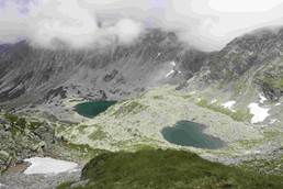
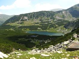 Câlcescu
Lake Duration :
7-8 h
Câlcescu
Lake Duration :
7-8 h
Go
by car and park in the saddle Urdele near the main road. The trail is marked
with a red band sign. It starts with a steep climb on the path to the Iezer
Peak (2157m), followed by a path under the Mohorul Peak (2337m). A slight descent in the saddle of Mohorul,
then over the Pleșcoaia Peak (2250m) and the Pleșcoaia
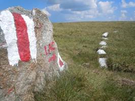
saddle. When you arrive at an arrow made of white stones and a rock with
the inscription “LAC” you can start the
descent to the lake, on the trail marked with red triangle in the upper part.
The descent is steep, on scree. You will see first a few small lakes, then the
spectacular Câlcescu Lake (1920m). Return the same way.
Alternatively,
to avoid the scree on the red triangle shortcut, you can continue on the main
trail marked by the red band sign, over the peaks Setea Mare and Setea Mica
till the saddle named Saua Piatra Tăiata, from where there is trail going
down to the Câlcescu Lake, marked by red cross; add
2-3 hours to the total time.
Alternative
trail, the shortest possible (duration 4 h): Go by car till close to Obârșia
Lotrului. Park near the road at the trail head (could continue by car another
2km on a forest road). The trail is marked with red cross. Ascent 2h30 through
the forest, descent 1h30 on the same trail.
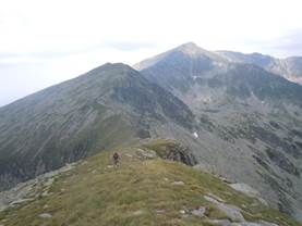 Parângu Mare Peak (2519m) Duration : 10 h.
Go
by car and park in the saddle Urdele near the main road. The trail is marked
with a red band sign. It starts with a steep climb on the path to the Iezer
Peak (2157m), followed by a path under the Mohorul Peak (2337m). A slight descent in the saddle of Mohorul,
then over the Pleșcoaia Peak (2250m) and the Pleșcoaia saddle.
Continue over the Setea Mare Peak (2365m) and the Setea Mica Peak (2278m).
Descend in the saddle Saua Piatra Tăiata, where the trail branches.
Continue on the red band sign, on the perpendicular ridge that goes up and down
over the peaks Lesu (2375m), Păclișa (2335m) and Gruiu (2345m). From
the Gruiu saddle, there is a last steep ascent till
the Parângu Mare Peak (2519m). Return the same way. (5h to go, 4h30 to return)
Alternative
trail for the Parângu Mare Peak (2519m),
duration 8-9 ore: go by car till Obârșia Lotrului (25km), then to Cabana
Groapa Seacă (12km), approximatively one hour drive. Then take the trail
marked with red dot. There is a forest road 4km (possible by AWD car). The
trail goes up through the forest till the refuge named Refugiul Agățat. Then it climbs in the alpine zone to the
lake Zănoaga Stânei, where you will see the remains of a plane fallen in
1970. Then there are three beautiful lakes
Roșiile, Lung and Mândra. The trail marked with red dot
goes around the Mândra lake
and climbs steeply to the Gruiu saddle. From there,
take the red band trail till the Parângu Mare Peak.
Return the same way.
 Petrimanu Lake Duration: 10 h
Park
on the Transalpina road behind the Păpușa Peak near the indicator with the
inscription “Lacul Petrimanu
5h”.
The trail is marked with red band signs. It goes up slightly over the Cioara Peak (2123m), and near the peaks Galbenul and Mușetoaia.
Then it goes up near the
Micaia Peak (2186m) where the signs might get lost, then it
descends to the Pristosul Peak (2075m) till the saddle Curmatura Oltețului.
From there, a steep descent goes to the Petrimanu Lake on a road. Return the
same way. (5h to go, 5h to return).
 Micaia
Peak (2136m) Duration: 5-6 h
Micaia
Peak (2136m) Duration: 5-6 h
A
shorter version of the trail to Petrimanu Lake. Go up the Micaia Peak and
return the same way marked by red band signs.
Tourist attractions (to visit by
car):
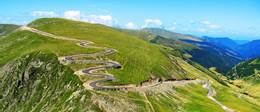 Transalpina Road
(DN 67C), known
as the Road of the King, traverses the Parâng
Mountains, through Rânca, and connects Oltenia to Transylvania. It is the road at the highest
altitude in Romania, reaching 2145 m altitude in the Urdele pass. It starts in
the village Bengeşti-Ciocadia in the Gorj county
and it goes till Sebeş in the Alba county. Cabana Transalpina is on the
Transalpina road (DN 67C km 34+800) at 20 km from Novaci and 25 km from Obârșia
Lotrului.
Transalpina Road
(DN 67C), known
as the Road of the King, traverses the Parâng
Mountains, through Rânca, and connects Oltenia to Transylvania. It is the road at the highest
altitude in Romania, reaching 2145 m altitude in the Urdele pass. It starts in
the village Bengeşti-Ciocadia in the Gorj county
and it goes till Sebeş in the Alba county. Cabana Transalpina is on the
Transalpina road (DN 67C km 34+800) at 20 km from Novaci and 25 km from Obârșia
Lotrului.
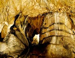 The cave Peștera
Muierilor:
From Cabana Transalpina go by car to Novaci (20km), then to Baia de Fier (8
km). You can also visit the cave Peștera
Polovragi, the monastery Polovragi and the Olteț canyon, which are in
same area.
The cave Peștera
Muierilor:
From Cabana Transalpina go by car to Novaci (20km), then to Baia de Fier (8
km). You can also visit the cave Peștera
Polovragi, the monastery Polovragi and the Olteț canyon, which are in
same area.
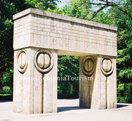 Complexul Constantin Brâncuși, Tg. Jiu
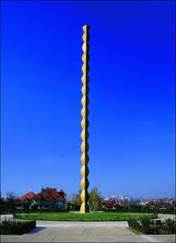
From
Cabana Transalpina, go to Novaci (20km) and then to Tg. Jiu (50km). You can
visit the famous sculptures The Kiss Gate, The Table of Silence and The
Infinite Column. Constantin
Brâncuși is a famous Romanian sculptor who lived in France
(1878-1957).
Biking trails:
Novaci
– Cabana Transalpina: on the Transalpina road, 20 km climb. Or descend in the
opposite direction.
Cabana
Transalpina – Cabana Obârșia Lotrului: on the Transalpina road through the
mountain pass Urdele. Then there are 14 km at 2000m altitude, slightly up and
down, till the saddle Saua Stefanului, followed by a steep descent to Obârșia
Lotrului. 25 km in total.
Could
continue to the Vidra lake,
then to the tourist resort Voineasa.
Or
could continue to Oașa, Șugag, Sebeș. Or to Jina, Sibiu. Or to
Valea Jiețului, Petroșani.
For
mountain bikes (MTB):
Could
adapt the above mountain trails.
Other
ideas:
Start
from Rânca from the old ski slope M1 or from the TV tower - The graphite mine –
The cave Peștera Muierilor in Baia de Fier.
The Strategic Road: leave the
Transalpina road on the saddle Saua Stefanului, and continue on an unpaved road
over the 2000m peaks: Bora, Puru, Pietrele, and Fratoșteanu, to end up in
Ciunget, and then in the tourist resort Voineasa. Trail